
BREAKING: Large, Destructive Tornado Ongoing Near St. Louis, Missouri — Residents Urged to Take Immediate Shelter
ST. LOUIS, MO — MAY 16, 2025 — A violent and destructive tornado is currently tearing through the heart of the St. Louis metropolitan area. Meteorologists and storm spotters confirm that this tornado is large, fast-moving, and likely producing wind speeds in excess of 130 miles per hour. The situation is unfolding rapidly, with emergency services and weather officials urging all residents in the storm’s path to SEEK IMMEDIATE SHELTER.
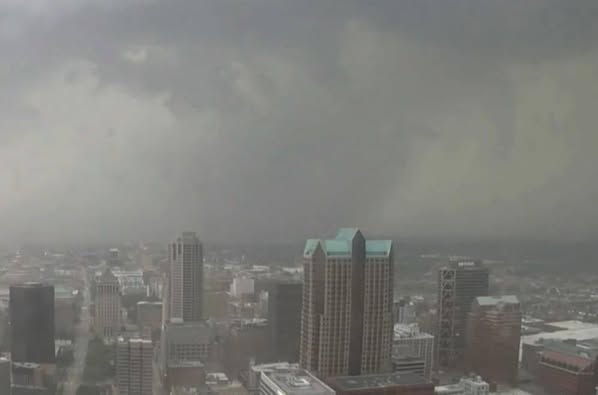
The National Weather Service issued a Tornado Emergency for the region at approximately 6:45 PM local time, the highest level of tornado alert, indicating that a confirmed large and destructive tornado was on the ground and heading through densely populated areas. Multiple reports have confirmed significant structural damage in several neighborhoods, including uprooted trees, toppled vehicles, and widespread power outages. Early footage from storm chasers shows a wide, wedge-shaped tornado moving ominously across highways and neighborhoods.
URGENT WARNING TO RESIDENTS:
If you are in the path of this storm, go to the lowest level of your home immediately — a basement or storm cellar is ideal. If that is not available, seek shelter in a small, windowless interior room or hallway on the lowest floor, such as a bathroom or closet. Do not attempt to drive through the storm, as conditions are rapidly deteriorating and visibility is near zero in many areas.
This tornado is part of a larger severe weather outbreak affecting the central U.S., as the peak of tornado season has now shifted into the Midwest. St. Louis and surrounding counties have been under a Tornado Watch for much of the day, but few expected such a potent storm to strike directly at rush hour, complicating evacuations and emergency response efforts.
Eyewitness Accounts and Damage Reports
Residents across the metro area have shared harrowing images and videos on social media showing debris flying through the air, flattened homes, and dark, swirling clouds descending upon urban and suburban communities.
Several major highways, including portions of I-70 and I-64, are reported to be blocked by debris or disabled vehicles. Lambert-St. Louis International Airport has suspended operations until further notice. First responders are working to assess damage and reach people who may be trapped in collapsed structures.
What We Know So Far:
-
Time of touchdown: Approximately 6:30 PM local time
-
Estimated wind speed: Likely over 130 mph, potentially EF-3 or stronger
-
Confirmed sightings: Numerous, with radar and spotter confirmation
-
Areas impacted: Central and northern St. Louis metro, including suburbs such as Hazelwood, Ferguson, and Florissant
-
Power outages: Tens of thousands without power, with utility crews unable to begin repairs until the storm passes
-
Emergency services: Overwhelmed in some areas; rescue efforts delayed due to ongoing dangerous conditions
Looking Ahead
Meteorologists warn that the threat is not over. Additional severe storms are developing to the southwest and could impact more of Missouri and Illinois into the evening. There is potential for more tornadoes, large hail, and damaging straight-line winds overnight.
This tornado marks one of the most serious weather events to strike the St. Louis area in recent memory, recalling memories of the devastating 2011 tornado that struck the airport and surrounding neighborhoods. Local leaders have activated emergency operations centers and are coordinating with state and federal agencies for a disaster response.
Final Word
This is a life-threatening situation. If you are in or near the affected area, take cover now. Monitor local news, NOAA Weather Radio, or trusted weather apps for continuous updates and emergency instructions.
Stay tuned for more details as the situation continues to unfold. Our thoughts are with everyone affected by this powerful and terrifying storm.