
Severe Weather Alert: Elevated/High Risk Today
As we head through the day, all eyes are on a powerful line of scattered severe storms pushing in from the west, riding just ahead of a strong cold front. This setup is primed to bring significant weather impacts across the region, with the risk level now upgraded to elevated/high for many parts of the Carolinas.
What to Expect:
This is not your average afternoon storm setup. We’re talking about a fast-moving system that has the potential to produce:
-
Widespread damaging wind gusts (50–70 mph possible)
-
Large hail, especially in the most intense cells
-
And while less likely, an isolated tornado cannot be ruled out
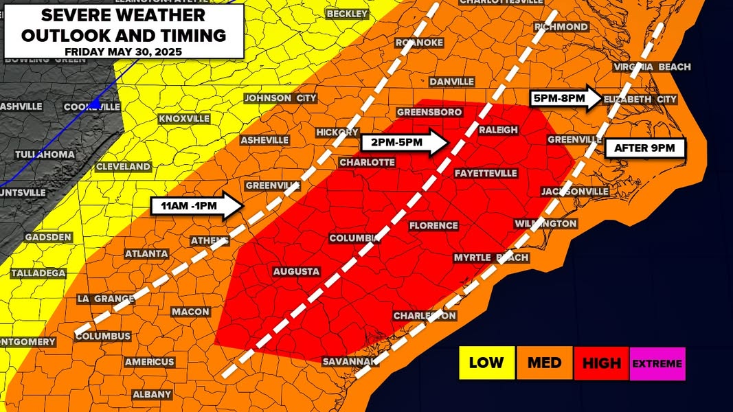
These storms will be scattered at first, but could quickly organize into a more defined line or squall, especially during peak heating this afternoon and into the early evening hours. The primary threat remains damaging straight-line winds, which could knock out power, bring down trees, and make travel dangerous during the commute.
Timing & Coverage:
-
Expect the first cells to arrive by early afternoon in western areas, spreading eastward through the late afternoon and evening.
-
The Charlotte metro and surrounding areas could see the worst conditions between 3 PM and 8 PM, depending on the storm speed.
-
Be weather-aware all day, especially during the evening commute when conditions could rapidly deteriorate.
Safety Tips:
-
Secure outdoor furniture, trash cans, and anything that could become a projectile.
-
Stay indoors and away from windows during storms.
-
Have multiple ways to receive warnings: weather radio, mobile alerts, WCNC updates, etc.
-
Keep flashlights and extra batteries handy in case of power outages.
🌪️ Tornado Threat?
While not widespread, the atmosphere has just enough spin and instability that an isolated tornado or two is possible, especially in areas where storms interact with localized boundaries or gain rotation. Stay vigilant.
🎥 VLOG Coming Soon!
Stay tuned — a detailed VLOG with radar breakdowns, timing updates, and safety advice is coming your way shortly. Make sure you’re following and subscribed so you don’t miss it!