


 | Today's Date:




DeSantis Expands Florida Flood Emergency to 14 Counties as River Rises
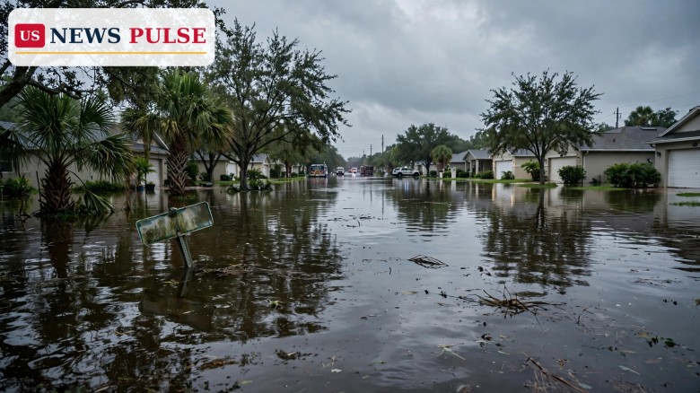
Florida's flood emergency has doubled in size. Governor Ron DeSantis signed Executive Order 26-228 on Wednesday, November 4, 2026, widening the state's flood emergency from seven counties to 14, as the St. Johns River is forecast to keep rising for weeks. The order adds Glades, Hendry, Lake, Okeechobee, Palm Beach, Seminole and Volusia to the original seven from Executive Order 26-227, signed November 2: Brevard, DeSoto, Hardee, Highlands, Indian River, Martin and St. Lucie.
Brevard County is shifting from rescue to recovery, after about 160 rescues by sheriff's deputies and state Fish and Wildlife officers, some Palm Bay homes reporting up to five feet of water, and rainfall the National Weather Service called a 1-in-1,000-year event, with almost 24 inches at Malabar in 24 hours and almost 20 inches at Palm Bay. That water is now draining north toward Jacksonville, keeping the St. Johns high for weeks.
Key Points
- Governor Ron DeSantis signed Executive Order 26-228 on November 4, 2026, expanding Florida's flood emergency from 7 counties to 14.
- New counties: Glades, Hendry, Lake, Okeechobee, Palm Beach, Seminole and Volusia, joining the original seven from Executive Order 26-227.
- The order cites record rain in Palm Beach County, including more than 19 inches in 12 hours in Riviera Beach.
- The National Weather Service forecasts minor to moderate St. Johns River flooding for several weeks as Brevard's rainfall drains north toward Jacksonville.
- Near Cocoa, moderate flooding was occurring Wednesday evening, with major flooding forecast late in the week, and water approaching low-lying homes in Silver Pines at 17 feet.
What Happened
The new order formally widens the emergency declared two days earlier. The original order covered seven counties in central and south Florida after a low-pressure system brought heavy rain from October 31 to November 2. The expansion stretches the zone from the Treasure Coast and Space Coast inland and northward along the St. Johns River basin.
Unlike a hurricane that passes in a day, this flood is draining slowly. Rain that fell in extraordinary totals in southern Brevard and parts of Palm Beach County is moving through rivers, canals and low-lying ground toward the north, so communities along the St. Johns, which flows north through central Florida to Jacksonville, could face elevated water for weeks even without further heavy rain. In Brevard, officials said Wednesday the county was moving from rescues to recovery, but Wednesday evening warnings already showed moderate flooding near Cocoa, with a rise to major flooding forecast late in the week.
Background and Context
The flooding began with a slow-moving low-pressure system that parked over Florida in late October. Southern Brevard bore the brunt: Malabar recorded almost 24 inches in 24 hours and Palm Bay almost 20 inches, totals characterised as a 1-in-1,000-year event, meaning rainfall of that intensity has roughly a one-in-a-thousand chance in any given year at that location. Flash flood emergencies followed, roads closed, schools shut, and polling places were moved on Election Day, November 3, as voters in seven counties were directed to temporary locations. Two deaths in Palm Bay were linked to the flooding in earlier reporting.
For how the crisis first unfolded, see our report on the flash flood emergency as 15 to 20 inches of rain swamped Palm Bay, and on how flooding moved Election Day polling places in Brevard County. Palm Beach County, now added to the emergency, also recorded extraordinary rain: more than 19 inches in 12 hours in Riviera Beach, a rate that overwhelms drainage designed for far smaller storms, leaving water to sit in streets, yards and homes for days or weeks.
Florida Flood Emergency Expands Across the State
The expansion matters because a state of emergency unlocks coordination and resources that individual counties cannot easily provide alone. It allows state agencies to deploy personnel and equipment, eases procurement and mutual-aid arrangements, and signals to federal partners that Florida is managing a large, multi-county event.
The geography of the order tells the story of the flood. The original seven counties covered the areas first hit by the heaviest rain and Election Day disruption; the seven added counties extend that zone south, inland and north, following both the Palm Beach rainfall and the St. Johns River's path toward Jacksonville. That river is now the central concern: one of the few major US rivers that flows north, its slow, flat course means floodwater moves sluggishly, so Brevard's record rainfall adds volume to a system already swollen by weeks of wet weather. For homeowners nearby, duration is the danger, as water staying for days can undermine foundations, ruin electrics, breed mould and keep roads closed.
Reactions and Official Response
State officials framed the expansion as a response to both the rainfall already recorded and the river forecast ahead. The order points to the record-breaking rain in Palm Beach County and to the National Weather Service outlook for the St. Johns, tying the declaration directly to measured rainfall and river forecasts. Locally, Brevard's shift from rescue to recovery marks a change in operations, not an end to the emergency: recovery involves damage assessments, debris removal, road repairs, checks on water and wastewater systems, and help for residents whose homes were inundated.
Why It Matters
First, the expansion confirms this is not a single-county, single-day storm, but a multi-week, multi-county disaster whose worst effects in some places are still to come; the river forecast, not just rain already fallen, is driving the response. Second, it shows how extreme rain cascades: water from southern Brevard and Palm Beach does not disappear, it moves downstream, threatening communities that saw far less rain themselves. Third, it reminds us how quickly infrastructure can be overwhelmed: drainage, roads and wastewater networks are built for regular storms, not 1-in-1,000-year rainfall, and the recovery bill for homes, roads and businesses will grow accordingly.
What Happens Next
Forecasters will watch the St. Johns near Cocoa and other gauges along its course. If the river reaches major flood stage late in the week as forecast, roads in low-lying areas will flood and water will approach homes in places such as Silver Pines. Residents there should monitor National Weather Service warnings and county alerts, and be ready to move vehicles, valuables and themselves to higher ground if advised.
Frequently Asked Questions
Which counties are covered?
Fourteen: Brevard, DeSoto, Hardee, Highlands, Indian River, Martin and St. Lucie, plus Glades, Hendry, Lake, Okeechobee, Palm Beach, Seminole and Volusia, added November 4.
What is Executive Order 26-228?
The order signed by Governor Ron DeSantis on November 4, 2026, expanding the flood emergency from seven counties to 14, following Executive Order 26-227 on November 2.
How long will St. Johns River flooding last?
The National Weather Service forecasts minor to moderate flooding for several weeks, as Brevard's record rainfall drains north toward Jacksonville.
How much rain fell?
Almost 24 inches at Malabar in 24 hours and almost 20 inches at Palm Bay, a 1-in-1,000-year event; Riviera Beach recorded more than 19 inches in 12 hours.
Is Brevard still in rescue mode?
No. Brevard is shifting to recovery after about 160 rescues, but flooding remains a threat, especially along the St. Johns near Cocoa.
Leave a Comment