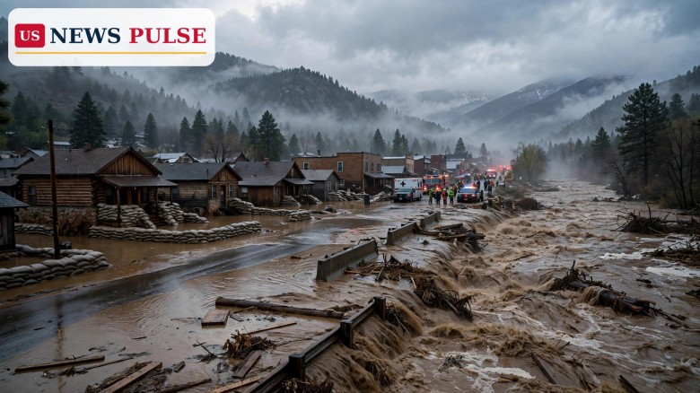
Pagosa Springs flood evacuations were ordered across low-lying parts of Archuleta County, Colorado, on Sunday morning, November 1, 2026, as forecasters warned that the San Juan River could climb to nearly 20 feet in the early hours of Monday, a level that would break historic records for the mountain town. The urgent Sunday update from county officials told residents in evacuation zones not to wait for the water to rise and not to wait for another warning, a blunt message that reflected how quickly the situation had escalated overnight as a new atmospheric river storm poured rain onto ground already saturated by last week's floods.
The evacuation order hardened on Sunday morning after the National Weather Service revised its flow predictions for the San Juan River late on Saturday night. The new forecast put the river at nearly 20 feet in Pagosa Springs in the early hours of Monday morning, well above the 17-foot peak that Pagosa Springs town manager David Harris had described at an emergency meeting on Saturday. That Saturday figure was already alarming: last week's flood peaked at 15 feet, and it destroyed roads and buildings and forced thousands of residents across the Southwest to evacuate.
Archuleta County's Sunday morning update was unambiguous. It said: 'If you are in an evacuation zone, you must leave now. This includes all low-lying areas along the San Juan, Rio Blanco, Navajo, and Piedra Rivers. Do not wait for the water to rise. Do not wait for another warning. Leave now.' The county said it was bringing in additional resources to help with search and rescue, including ground and air support and the Colorado National Guard, a step that signals officials expect rescues to be difficult, or impossible, once the river peaks.
Officials in Pagosa Springs and Archuleta County have issued a flood warning for the San Juan River for Sunday and Monday. A winter weather warning is also in effect for the same period for higher elevations, where up to 18 inches of snow could fall. The combination of heavy rain at lower elevations and snow higher up is a familiar and dangerous pattern in the San Juan Mountains, where warm, moisture-laden air can melt snowpack even as it adds rain to already swollen rivers.
Pagosa Springs has already flooded repeatedly in recent weeks. The San Juan River has seen major flooding three different times since last October, according to local reporting, and last week's event alone was severe enough to destroy roads and buildings and force the evacuation of thousands of people across the Southwest. The latest storm is striking the same saturated catchments, which is why forecasters are warning of rapid runoff: rain falling on wet ground, rather than soaking in, runs straight into rivers.
The broader storm is an atmospheric river, sometimes called a Pineapple Express when its moisture originates near Hawaii, and it is delivering a prolonged period of widespread rain across Arizona, Utah, New Mexico and Colorado. Forecasters expected roughly three-quarters of an inch to 2.5 inches of rain in lower-elevation parts of Arizona, with higher amounts near foothills, and around 3 inches of rain for Pagosa Springs and Archuleta County from Sunday into Monday morning. In southern Colorado, several rivers were forecast to reach minor flood stage, but the San Juan at Pagosa Springs was singled out as the most severe threat, with a Particularly Dangerous Situation flood warning in effect.
Independent forecaster Jeff Givens, known as the Durango Weather Guy, projected an even higher crest of 22 feet overnight, though KSUT Public Radio noted it had not been able to corroborate that figure with its own data. The gap between the official near-20-foot forecast and the independent 22-foot projection underlines the uncertainty in river forecasting during an active storm, but both numbers point in the same direction: well above last week's 15-foot peak, and above anything the town has recorded before.
On Saturday, Harris told KSUT that the town had positioned barricades and equipment in anticipation of extreme flooding, and that Pagosa Springs was opening shelters and issuing mandatory evacuations for all areas within the town limits. Archuleta County's mandatory evacuation orders for low-lying areas along the four rivers remain in effect, and county and town officials are warning residents to evacuate immediately.
Vicki Shaffer of the Archuleta County Sheriff's Office gave residents a stark reason to leave while they still can. 'We understand some people may not choose to evacuate,' she said. 'We just want the public to understand that help may not be immediately available to rescue people tomorrow evening and Monday morning.' That warning matters because the peak is expected in the early hours of Monday, when darkness, debris-filled water and closed roads can make rescue operations slow or impossible.
Residents who are not in an evacuation zone are still being urged to stay away from rivers, flooded roads and low-water crossings. Flood water can hide washed-out roads, carry debris and downed power lines, and rise far faster than it appears to. Officials have repeatedly stressed that drivers should never attempt to cross flooded roads, and that the safest action is to move to higher ground well before the river crests.
Local officials have framed the weekend as a race against the river. Harris's Saturday emergency meeting set out the town's preparations, from barricades and equipment to shelters, while the county's Sunday update escalated the language from preparation to immediate departure. The decision to bring in the Colorado National Guard, alongside ground and air search-and-rescue support, shows that the county is preparing for a scenario in which some residents do not leave in time, or become trapped by rising water overnight.
Weather forecasters have also warned that the danger is not confined to Pagosa Springs. The National Weather Service's Grand Junction office said flood watches continued for southeastern Utah and southwestern Colorado, and forecasters warned of significant river flooding across southern Colorado, with the Rio Grande at Monte Vista forecast to crest on Tuesday more than two feet above its previous highest crest, set in June 1949. The scale of those forecasts explains why this storm, rather than being treated as a routine autumn rain event, is being handled as a multi-day emergency.
A crest near 20 feet would not just be a new record for Pagosa Springs; it would be a second devastating flood in little more than a week for a community still clearing debris from the last one. Roads, bridges, water systems and homes that survived last week's 15-foot peak may not survive a crest five feet higher, and the damage could cut off access to parts of the town for days. For a small mountain community, that kind of repeated damage strains shelters, road crews and emergency services, and it raises hard questions about rebuilding in the same flood-prone corridors.
The event also illustrates a wider pattern across the Southwest this autumn: repeated atmospheric river storms falling on saturated ground, each one producing more runoff than the last. When rivers are already high and soils are already full, even a moderate amount of additional rain can produce major flooding. That is why forecasters and county officials are urging evacuation now, rather than waiting to see whether the river actually reaches 20 feet.
The critical hours are Sunday night into early Monday morning, when the San Juan River is forecast to crest. Officials will be watching river gauges through the night, and further evacuation orders, road closures and shelter openings are possible if the forecast worsens or if the river rises faster than expected. Residents should monitor Archuleta County and National Weather Service updates, keep phones charged, and be ready to move to higher ground at short notice.
After the crest, the focus will shift to damage assessment, road and bridge inspections, and restoring water and power services. Last week's floods destroyed roads and buildings across the Southwest, and a higher crest this time could leave a longer repair bill and a longer recovery. For now, though, the message from officials is simple and urgent: if you are in an evacuation zone, leave now.
Pagosa Springs is a town in Archuleta County in southwestern Colorado. The mandatory evacuation orders cover low-lying areas along the San Juan, Rio Blanco, Navajo and Piedra rivers, and all areas within Pagosa Springs town limits.
The National Weather Service revised its forecast overnight to nearly 20 feet in the early hours of Monday morning, breaking historic records. On Saturday the forecast peak was 17 feet, and last week's peak was 15 feet.
Archuleta County says residents in evacuation zones must leave now, without waiting for the water to rise or for another warning. Officials warn that rescue help may not be immediately available on Sunday evening and Monday morning.
Yes. A winter weather warning is in effect for higher elevations for Sunday and Monday, with up to 18 inches of snow possible, even as rain falls at lower elevations.
See our earlier Southwest flooding coverage: Arizona flash floods, rescues and one death as Southwest braces for more rain and Four Corners flood risk warning for November 1 heavy rain.
Leave a Comment



 | Today's Date: