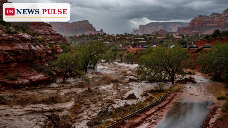
Sedona flood evacuations were ordered on Sunday morning, November 1, 2026, as Oak Creek surged past its flood stage and forced residents in the eastern part of the Arizona city to leave immediately. The City of Sedona placed evacuation zones 8, 9 and 10 in GO status, the highest level of Arizona's Ready, Set, Go system, meaning danger was imminent and life-threatening and residents should evacuate without delay. The order came as a powerful atmospheric river storm poured rain onto already saturated ground across northern and central Arizona, the same storm system that has already forced mass evacuations in Pagosa Springs, Colorado, and put highways across the Flagstaff region out of service.
The evacuation order was reported at 11:30 a.m. Eastern time on Sunday by AZCentral, citing a post from the City of Sedona's Facebook page. Flash flooding in Oak Creek Canyon triggered mass evacuations in Sedona, the report said, with zones 8, 9 and 10 ordered to evacuate to Sedona Red Rock High School. The zones cover the eastern side of Sedona, along State Route 179 and surrounding Oak Creek. Other zones were not ordered to evacuate, but the city warned residents to stay away from creek beds and washes and not to cross when rushing water is on the road. Residents were encouraged to subscribe to emergency alerts by texting the word REDROCKS to 888777.
A detailed local listing published by Sedona.biz named the streets and properties in GO status: Trails End Road and Trails End Lane, Purtymun Lane, Lomacasi Lane, Art Barn Road and Art Barn Lane, Arroyo Roble Drive, Amara Lane, Little Lane, L'Auberge Lane, Blackhawk Lane, Newcastle Lane, Oak Creek Mobilodge, Copper Cliffs Drive and Copper Cliffs Lane, Sycamore Road, the Villas at Poco Diablo Resort, the Center for the New Age, Rancho Sedona RV park, houses north of the Rancho Sedona RV park on Bear Wallow Lane, and any other properties adjacent to Oak Creek. The listing said residents could go to the Middle/High School for information and updates, with shelter details to come, a wording that reflects how fast the situation was developing on Sunday morning.
The National Weather Service office in Flagstaff had already issued a Flash Flood Warning at 8:15 a.m. Mountain Standard Time on Sunday, in effect until 11:15 a.m. for Coconino and Yavapai counties. Doppler radar and automated rain gauges indicated heavy rain across the warned area, with between 1.25 and 2.5 inches already fallen, and the warning said flash flooding was ongoing or expected to begin shortly. Its hazard was described in the starkest terms the service uses for this kind of event: life-threatening flash flooding of creeks and streams, normally dry washes, urban areas, highways, streets and underpasses. Low-water crossings were flagged as dangerous, and drivers were told not to attempt to cross flooded roads.
Sedona sits in Oak Creek Canyon country, where a desert city is threaded by a creek that can rise with terrifying speed when heavy rain falls on steep, rocky catchments. That geography is central to Sunday's danger. The same atmospheric river storm that is drenching the Southwest has already saturated soils across Arizona, Utah, New Mexico and Colorado, so rain that would normally soak in instead runs straight into creeks and rivers. A Flood Watch issued by the National Weather Service in Flagstaff at 1:13 a.m. Mountain Standard Time on October 31, in effect until 5 a.m. on November 2, warned of flash flooding in creeks, normally dry washes, swimming holes and recently burned areas, with low-water crossings at risk of flooding, and said a second round of rain and isolated thunderstorms was expected from Saturday night through the early hours of Monday, with an additional 1 to 3 inches possible on already saturated ground.
The gauge numbers on Sunday morning show why officials moved from watch to evacuation. At Sedona, Oak Creek reached 15.06 feet at 7:45 a.m., more than a foot above its 14-foot flood stage. Downstream at Cornville, the creek stood at 8.88 feet at 8 a.m., above its 8-foot flood stage. The Flash Flood Warning listed a long string of places that would experience flash flooding, including Sedona, Cornville, Jordan, Page Springs, Bignotti, Indian Gardens, Pine Flats, Uptown Sedona, Sedona Airport, Red Rock State Park, Slide Rock State Park, West Fork of Oak Creek, Red Rock-Secret Mountain Wilderness, Cathedral Rock and Oak Creek Vista Overlook, and named the affected highways as State Route 179 between mile markers 310 and 313 and State Route 89A between mile markers 373 and 384 and between 386 and 390.
This is not Sedona's first brush with Oak Creek flooding, and it is not an isolated incident in this storm. Earlier in the weekend, the same system forced mandatory evacuations in Pagosa Springs, Colorado, where the San Juan River is forecast to crest near 20 feet early on Monday, breaking historic records. Fox Weather, updating its cross-country storm coverage at 11:29 a.m. Eastern on Sunday, reported that portions of Sedona were being urged to evacuate as Oak Creek rapidly rose, and that the wider storm was expected to bring major flooding to the Four Corners region on Sunday, with a Level 3 out of 4 flash flood risk, before sweeping into the central United States for Election Day. The Sedona evacuations are therefore a distinct, local emergency inside a much larger regional flood event, not a repeat of the Colorado story.
By late Sunday morning the flooding had closed major routes around Flagstaff. A FlagScanner breaking alert, last updated at 10:17 a.m. on Sunday, November 1, listed three closures: Interstate 17 northbound at State Route 179, Interstate 17 southbound at milepost 337 near the Flagstaff airport, and State Route 89A between Sedona and Kachina Village, from mileposts 375 to 397. Motorists were advised to expect delays and avoid travelling in those areas, the alert said, and there was no estimated time to reopen the highways. The National Weather Service on Sunday morning had issued a Flood Watch for central and northern Arizona as rainfall was expected to continue through Sunday evening, and the alert repeated the warning that has become familiar across the Southwest this weekend: never drive into flooded roads or washes, because hazards can be submerged and a few inches of running water can sweep away a car.
The closures matter beyond Sedona itself. Interstate 17 is the main north-south artery between Phoenix and Flagstaff, and State Route 89A is the scenic and practical link between Sedona and Flagstaff through Oak Creek Canyon. Closing both at once, on a Sunday when tourists and weekend visitors are moving through Red Rock Country, cuts off the usual escape routes and forces drivers onto longer detours, if any are open. For residents under GO orders, the closures also underline why officials urged immediate departure: roads that are passable in the morning can become impassable within an hour when a creek is still rising.
No single official quote from a Sedona mayor or fire chief had been published in the Sunday morning accounts used for this article, and this article invents none. What the official record does show is a consistent, escalating message from the city, the county system and the weather service. The City of Sedona's Facebook post, as reported by AZCentral, moved zones 8, 9 and 10 to GO status and gave a single destination, Sedona Red Rock High School. Sedona.biz, publishing the city's zone list, explained the system in plain terms: Ready means be aware and prepare, Set means significant danger and consider voluntarily relocating, and Go means danger is imminent and life-threatening and residents should evacuate. The National Weather Service's warning added the physical reason for that urgency, with measured rainfall, gauge heights above flood stage, and a list of creeks, washes and highways already affected.
The evacuation-zone map maintained by Sedona Matters, which updates from the City of Sedona's Nixle alerts, recorded the same status at about 7:45 a.m. Mountain Standard Time on Sunday: GO for zones 8, 9 and 10, covering creek areas at flood risk. That independent check, timed before the AZCentral report, confirms that the GO order was in place early on Sunday morning and was not a later escalation. Residents were also given a simple way to stay informed, by texting REDROCKS, or the zip code 86336, to 888777 for city alerts, a detail that matters when power, internet or road access can fail during a flood.
A GO evacuation in Sedona is not a precautionary drill. It means officials believe water is already at a level where staying beside Oak Creek could become life-threatening, and where rescue may become difficult or impossible once roads close and the creek rises further. The gauge readings support that judgment: a creek more than a foot above flood stage at Sedona, and still above flood stage downstream at Cornville, with more rain forecast through Sunday evening on saturated ground. For the neighbourhoods named in the order, including resorts, an RV park and homes directly beside the creek, the choice officials presented was stark: leave now, while routes are still open, or risk being cut off.
The wider significance is the pattern of this autumn in the Southwest. Repeated atmospheric river storms are falling on the same saturated catchments, each one producing faster runoff than the last. Pagosa Springs in Colorado, Sedona in Arizona, and the river forecasts for the Rio Grande and other southern Colorado rivers all point in the same direction: a region where flood records set last week are already being challenged this weekend. For emergency managers, that means evacuation orders, highway closures and shelter openings are no longer one-off responses to a single storm, but a rolling operation across several states at once.
The immediate question is whether Oak Creek keeps rising through Sunday evening, as the Flood Watch anticipates, or begins to fall once the heaviest rain passes. Further evacuation orders are possible if the creek rises further or if new areas beside Oak Creek, the Verde River or other northern Arizona waterways come under threat, and road closures on Interstate 17 and State Route 89A will remain in place until water recedes and road surfaces can be inspected. Residents who have evacuated should not return until the city lifts the GO order for their zone, even if the water looks lower, because creek levels can rise again with a new band of rain and because washed-out road surfaces and debris can remain hidden under muddy water.
After the water recedes, the focus will shift to damage assessment along Oak Creek, inspection of bridges, low-water crossings and the closed highways, and support for residents and businesses in the evacuated zones, including resorts and RV parks whose guests and residents were moved at short notice. For now, the official message is unchanged from Sunday morning: if you are in zones 8, 9 or 10, leave immediately; if you are elsewhere in Sedona, stay away from creek beds and washes, never cross rushing water on a road, and monitor City of Sedona alerts for the next update.
Evacuation zones 8, 9 and 10, covering the eastern side of Sedona along State Route 179 and surrounding Oak Creek. Named streets include Trails End Road, Purtymun Lane, Art Barn Road, Copper Cliffs Drive, Sycamore Road, Rancho Sedona RV park and the Villas at Poco Diablo Resort, plus any other properties adjacent to Oak Creek.
AZCentral, citing the City of Sedona's Facebook post, said zones 8, 9 and 10 were ordered to evacuate to Sedona Red Rock High School. Sedona.biz said residents could go to the Middle/High School for information and updates, with shelter details to come. Residents should follow the latest City of Sedona alert for their zone.
At Sedona, Oak Creek reached 15.06 feet at 7:45 a.m. local time on Sunday, above its 14-foot flood stage. At Cornville it stood at 8.88 feet at 8 a.m., above its 8-foot flood stage, according to the National Weather Service in Flagstaff.
Interstate 17 northbound at State Route 179, Interstate 17 southbound at milepost 337 near Flagstaff airport, and State Route 89A between Sedona and Kachina Village (mileposts 375-397), with no estimated reopening time as of Sunday morning.
See our coverage of the same storm system in Colorado: Pagosa Springs flood evacuations as San Juan River nears record 20 feet.
Leave a Comment



 | Today's Date: